A Rare Early-Season Polar Vortex Shift Is Currently Developing, and Experts Say Its Intensity Is Nearly Unprecedented for February
The first hint is the sound. Before you feel it on your skin, before the sky fully changes color, there is a faint hollow hush outside, like the world briefly inhaling and forgetting to exhale. On a late winter morning, you crack open the door expecting the familiar chill of February, but what is waiting feels different. The air has a sharp metallic edge, the kind that nips your nostrils and stings your lungs, even if the forecast the day before promised seasonal cold.
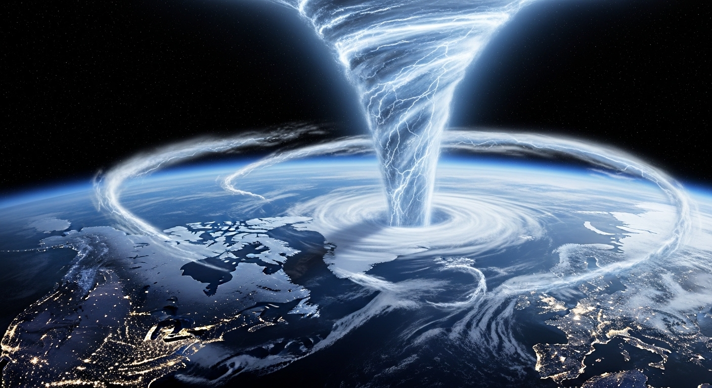
Somewhere far above your roof and the frozen sidewalks, the atmosphere has begun rearranging itself in a way that scientists are calling almost unprecedented for this time of year. A rare early-season polar vortex shift is brewing, and though you cannot see it, you are already living inside its story.
A River of Wind You Will Never See
Picture the planet from space on a clear winter night. The polar regions are cloaked in darkness, sea ice gleaming like fractured glass. High above that wilderness, around 20 to 50 kilometers up, sits an invisible crown of wind: the polar vortex. Despite the ominous name, it is not a monster storm spinning over your neighborhood. It is a vast, cold whirlpool of air that encircles the Arctic like a containment ring, keeping the deepest cold largely penned in near the pole.
Most winters, this upper-level vortex is a steady, if sometimes temperamental, guardian. It tightens, it loosens, it wobbles. The jet stream, that high-altitude river of wind that steers storms, ripples and bends but mostly stays within familiar bounds. We get cold snaps and thaws, snowstorms and rain, the usual weather dramas that fill small talk and local forecasts.
This year, something unusual is underway. High in the stratosphere, the polar vortex is being jostled, warmed, and twisted in a way that has experts leaning closer to their screens. It is early in the season for a disruption this intense, closer to mid-winter’s deep freeze than late winter’s gradual loosening. The atmospheric “lock” that usually holds the Arctic cold in place is starting to break, and it is happening earlier and more dramatically than climatologists expect for February.
When the Sky Warms From Above
The root of this rare shift is something with a deceptively gentle name: a sudden stratospheric warming, or SSW. Do not let the softness of those words fool you. In the upper atmosphere where the polar vortex lives, temperatures can swing by 40 to 50 degrees Celsius in just a few days. For a realm that usually changes slowly and quietly, that is like a thunderclap.
Powerful atmospheric waves generated down below by mountains, storm systems, and the contrast between continents and oceans surge upward through the troposphere. Some winters, those waves slam into the base of the stratosphere with just the right rhythm and energy. When they do, they can buckle the vortex, injecting heat and momentum and knocking the once-stable circulation off balance.
In simple terms, the top of the sky suddenly starts to warm while the ground below might still be shivering. The polar vortex, deprived of its icy fuel and battered by these upward waves, weakens. Sometimes it stretches like a rubber band. Sometimes it splits into smaller whirlpools, each wandering away from the pole.
That is what satellite data and weather models are catching right now: a developing disturbance, unusually strong for February, ripping into the vortex from above. Because what happens in the stratosphere does not stay there. It trickles downward over days to weeks, changing the pattern of winds and storm tracks that we feel where we live, breathe, and shovel our driveways.
The Slow-Motion Domino Effect
From the ground, it will not look like one single dramatic event. You will not see the sky turn a different color or hear some cosmic creak as the polar vortex shifts. Instead, the changes arrive in stages, like a series of subtle, then not-so-subtle, nudges to the weather pattern.
First, high-altitude winds begin to weaken. The jet stream, which usually races from west to east in relatively smooth arcs, starts to wobble more wildly. Its once-tidy flow buckles into exaggerated loops. In some places it bulges north, pulling mild air into regions usually locked in snow and ice. In others, it plunges south, opening a gate for Arctic air to spill far beyond its normal boundaries.
Over one or two weeks, the surface weather map starts to look increasingly contorted: persistent blocking highs here, stalled storm systems there, unexpected cold snaps and heat waves popping up side by side. What had been a familiar winter rhythm becomes syncopated and strange.
Meteorologists describe this as downward coupling, when stratospheric changes rearrange our day-to-day weather. For people on the ground it translates into lived experience: the shock of a freezing wind slamming into a city that had begun to taste early spring, or the surreal warmth melting snowbanks in a town that usually stays locked below freezing well into March.
This February, forecasters are seeing signs that such a chain reaction may already be set in motion, earlier and more intensely than records suggest is typical.
How This Year Stands Out
Climatologists spend their careers cataloging what the atmosphere usually does so they can recognize when it steps out of character. And this year, it is doing just that.
Based on reanalysis datasets and decades of upper-air observations, the current projected weakening of the polar vortex ranks near the most intense February events on record. It is not just the magnitude of the disruption that has people talking. It is the timing. Early to mid-winter is when a strong SSW is more common, not late February, when the stratosphere is usually inching toward its natural springtime breakdown.
Think of it as a mid-season plot twist hitting just as the story was supposed to begin wrapping up.
| Event Year | Month of Peak Disruption | Relative Intensity | Notable Surface Impacts |
|---|---|---|---|
| 2009 | January | High | Severe cold in Europe and parts of Asia |
| 2013 | January | Very High | Extended cold spells in Europe, delayed spring |
| 2018 | February | Very High | Beast from the East cold wave in Europe |
| 2021 | January | High | Historic cold in central US, energy grid stress |
| Current Year | February | Near-Unprecedented | Heightened risk of extreme swings, region-dependent |
Looking at such events side by side, one theme emerges: a major polar vortex disruption does not guarantee disaster, but it loads the dice. The atmosphere becomes more primed for unusual and sometimes severe conditions, especially for regions already prone to winter extremes.
What It Might Feel Like Where You Live
From the vantage point of satellites and models, the polar vortex shift is a grand, planetary-scale drama. But its meaning sharpens when you imagine how it might show up on your street, in your house, on the faces of people waiting for a bus.
If you live in the mid-latitudes of North America, Europe, or Asia, the main actors in your local story will be the jet stream and the position of high and low-pressure systems riding along it. Under a ridge, cities can bask in startling warmth for the season, sunlight pooling on sidewalks, coats unzipped, the faint scent of wet soil hinting at a spring that has not truly arrived. But under a trough, the air can be brutally cold, dense and dry, scraping across open skin and filling lungs with icy fire.
In some places, you might experience both extremes in rapid succession. A week that begins with slushy streets and dripping eaves could end with the creak of tree limbs hardened in deep freeze, the soft hiss of powder snow blown sideways under streetlamps.
For farmers and gardeners, the stakes are visceral. An early warm spell could coax buds out of dormancy, tricking fruit trees into waking up, only to be slammed by a hard frost when a lobe of polar air swings south. For energy systems, the risk lies in sudden spikes in heating demand when households that had begun to dial back the thermostat abruptly need full power again.
Yet not everyone will see the same side of this disrupted coin. One region might endure relentless cold while another, only a few thousand kilometers away, spends February in a strangely gentle embrace of mild air. The one common thread is a sense that the atmosphere has gone slightly off-script.
A New Normal or Just a Loud Exception?
Whenever something feels extreme or unusual, a near-automatic question rises: is this climate change? The honest answer is nuanced. The polar vortex itself is a natural feature of the planet’s circulation, and sudden stratospheric warmings have been recorded long before global temperatures began their modern surge.
Yet the backdrop on which these events play out has changed. The Arctic is warming faster than nearly anywhere else on Earth, its sea ice thinning, retreating, and reshaping the contrasts between cold pole and warmer mid-latitudes. Some studies suggest this altered background may, in certain conditions, make the vortex more vulnerable to disruption or change how those disruptions translate to surface weather. Other research is more cautious, emphasizing that natural variability still plays a powerful, sometimes dominating, role.
What most scientists agree on is this: as the climate system warms, we are loading the atmosphere with more energy and shifting old baselines. That does not erase the polar vortex, but it may tweak the script, stretching the range of what is possible, concentrating extremes, and making events like this stand out even more sharply.
You could think of it like a symphony played on slightly retuned instruments. The notes are familiar, but some sound sharper, some more dissonant, some uncomfortably loud.
Finding Our Place in a Moving Atmosphere
It is easy to think of the polar vortex as something distant and abstract, a phrase that spikes in search engines every few winters and then fades. But standing outside on a crisp February night, watching your breath bloom in the dark, you are literally inside the system it describes. Every gust that brushes your cheek is part of a global pattern, a spinning, often graceful, sometimes unruly circulation of air tracing invisible lines around a rotating sphere.
As this early-season polar vortex shift unfolds, we are reminded that our sense of normal is tied to patterns that are both fragile and resilient. Fragile because a disruption far above can reorder the weather we consider typical with astonishing speed. Resilient because despite these wild swings, the system as a whole is still governed by physics we can describe, measure, and increasingly predict.
The atmosphere is not just a background setting. It is an active character in our shared story. It touches food security, energy, infrastructure, and health. It shapes our memories: that winter when the snow piled higher than the mailbox, that February when the crocuses emerged and then vanished under ice.
In the coming weeks, as forecasts track the aftermath of this polar vortex shift, you may notice the weather feeling oddly amplified. Colder, warmer, stormier, or eerily still. You may step outside and hear that same strange hush, that sense of the world drawing in a breath before something changes. When you do, know that you are not just enduring random chaos. You are standing inside a living, shifting, swirling system whose rare moods can now be seen, named, and to a growing degree, understood.
And perhaps that is the most grounding part of this story: in a time of intensifying extremes, our ability to read the sky is deepening. We might not calm the polar vortex or stop its sudden lurches. But we can learn to listen better, to the data, to the models, to the quiet signals in the wind, and in listening, find ways to adapt, prepare, and live more wisely under the restless air that binds every one of us together.
Frequently Asked Questions
What exactly is the polar vortex?
The polar vortex is a large-scale circulation of very cold air high in the atmosphere, centered over the Arctic. It lives mainly in the stratosphere, well above the weather systems we experience directly, and is driven by the contrast between dark, deeply cooled polar regions and sunlit lower latitudes.
Does a polar vortex shift always mean extreme cold where I live?
No. A weakened or disrupted polar vortex increases the likelihood of unusual weather patterns including cold outbreaks, but the exact impacts depend on how the jet stream responds. Some areas may experience intense cold, others may be milder than normal, and some may see little change at all.
How long do the effects of a sudden stratospheric warming last?
The stratospheric disturbance itself can persist for weeks, and its influence on surface weather often unfolds over one to three weeks after the peak event. The altered patterns can linger for a month or more, but their strength and exact footprint vary from event to event.
Is this rare February event caused by climate change?
Climate change does not directly cause individual polar vortex shifts, which are part of natural variability. However, the warming Arctic and changing sea ice patterns may influence how often and how strongly the vortex is disturbed. Research is ongoing and there is not full scientific consensus yet.
What can individuals and communities do to prepare?
Preparation focuses on resilience to extremes: ensuring heating and power systems are robust, checking insulation, having plans for vulnerable populations during cold snaps, and supporting infrastructure that can handle both severe cold and sudden thaws. Staying informed with reliable weather updates is the most important step, especially in the weeks following a significant polar vortex disruption.