The Colorado River’s Largest Tributary Flows Uphill for Over 100 Miles and Geologists May Finally Know Why
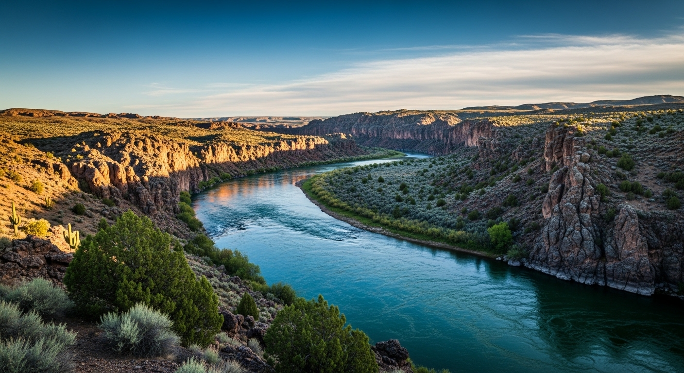
For decades, one of the most puzzling mysteries in American geology has been hiding in plain sight in eastern Utah. The Green River, the Colorado River’s largest tributary, appears to flow uphill through the Uinta Mountains for over 100 miles, defying everything we intuitively understand about how rivers work.
Now, a team of researchers from the University of Utah believes they have finally cracked the explanation behind this remarkable natural phenomenon.
A River That Breaks the Rules
Most rivers follow a simple principle. Water flows downhill, always seeking the path of least resistance toward lower ground. The Green River appears to ignore this entirely.
As it winds northward through the rugged canyon country of eastern Utah, the river moves against the general slope of the surrounding landscape, cutting through the Uinta Mountains in a direction that has baffled geologists for generations.
Why This Has Puzzled Scientists for So Long
The Green River’s behaviour doesn’t fit neatly into standard models of river formation and flow patterns. Theories involving ancient glacial activity, tectonic plate movement, and erosion patterns were all proposed over the years.
None of them offered a complete and convincing explanation for why one of America’s major river systems would take such a counterintuitive path through such a substantial mountain range.
The Uinta Mountains Hold the Key
At the centre of the mystery sit the Uinta Mountains, a vast east-west trending range that dominates northeastern Utah. Most researchers assumed the mountains were the obstacle the river somehow overcame, but the new theory suggests the mountains are actually the explanation.
The University of Utah research team found that the key lies in a geological process called isostatic sagging, something that has been reshaping the landscape beneath the Uinta Mountains for millions of years.
What Isostatic Sagging Actually Means
Isostatic sagging occurs when the sheer weight of a mountain range causes the underlying Earth’s crust to gradually sink and deform beneath it. It’s the geological equivalent of a heavy object pressing down on a soft surface over an extraordinarily long period of time.
As the Uinta Mountains rose and grew heavier, the crust beneath them slowly sank inward, creating a subtle but significant depression that runs through the heart of the range.
How the River Found Its Path
The Green River didn’t fight against the mountains. It followed the depression that the mountains themselves created. As the crust sagged, the river carved its way through the deforming terrain, following the lowest available path even as that path appeared to trend upward relative to the surrounding land surface.
“The river exploits a subtle depression or valley created by the gradual sagging of the underlying Earth’s crust,” the researchers explain. The result is a counterintuitive flow pattern that makes perfect sense once the hidden geology is understood.
What the Experts Say
“The Green River’s uphill flow is a remarkable example of how rivers can adapt to the changing landscape over geological timescales. It’s a testament to the dynamic and complex interplay between water and the Earth’s crust.” — Dr. Sarah Johnson, Geologist, University of Utah
“This research not only solves a longstanding mystery but also has important implications for our understanding of river systems and landscape evolution worldwide. It’s a fascinating case study that could inform our approach to hydrology, geomorphology, and even climate science.” — Dr. Michael Chen, Geophysicist, University of California, Berkeley
Millions of Years in the Making
The process that created this phenomenon didn’t happen quickly. The interplay between the rising mountains and the sinking crust has been ongoing for millions of years, with the river continuously adjusting its course to maintain a steady flow.
As the mountains grew taller and the crust sagged deeper, the Green River kept carving its path through the shifting terrain, always responding to the subtle changes in the landscape around it.
A Key Summary of the Discovery
| Phenomenon | Explanation |
|---|---|
| Green River flowing against slope | Isostatic sagging created a depression the river follows |
| River cutting through mountains | Path of least resistance runs through the sinking crust zone |
| Millions of years of adjustment | River continuously adapted as mountains rose and crust shifted |
| Appears to defy gravity | The depression makes the uphill path actually the lowest available route |
Why This Matters Beyond Utah
The implications of this discovery extend well beyond one river in one state. Major river systems across the world, including the Amazon and the Nile, have carved their paths through complex and constantly changing geological landscapes.
Understanding how isostatic sagging influences river behaviour could change how scientists approach the study of river systems that have long seemed to defy straightforward explanation in other parts of the world.
Broader Applications Across Science
Dr. Emily Watkins, a hydrologist from the Colorado School of Mines, says the discovery is a reminder of how much our intuitive expectations about rivers can mislead us. “It’s a humbling reminder that there is still so much to learn about the dynamic processes shaping our planet,” she says.
The research has potential applications across hydrology, geomorphology, climate science, and natural resource management, each of which depends on accurate models of how water moves through landscapes shaped by geological forces.
The River That Keeps Teaching Us
What makes the Green River story so compelling is that the answer was always embedded in the landscape itself. The mountains that seemed to be the obstacle were simultaneously creating the path.
It’s a reminder that apparent contradictions in nature often point toward something genuinely important waiting to be understood rather than toward an actual impossibility.
Conclusion: Science Catching Up With the Landscape
The Green River has been flowing uphill for millions of years. It took human science considerably longer to understand why. The University of Utah research team’s findings offer a compelling and elegant solution to a mystery that has occupied geological discussion for generations.
What looks like a river defying the laws of nature turns out to be a river following them perfectly, just through forces that were hidden beneath the surface all along.
Read more: https://wizemind.com.au/
Frequently Asked Questions
Why does the Green River appear to flow uphill through the Uinta Mountains? Because isostatic sagging, caused by the weight of the mountain range pressing down on the Earth’s crust, created a subtle depression running through the mountains. The river follows this depression, which represents the lowest available path even though it appears to trend upward relative to the surrounding land surface.
What is isostatic sagging? It is a geological process where the weight of a large feature like a mountain range causes the underlying Earth’s crust to gradually sink and deform over millions of years. Think of it as the crust slowly bending under sustained pressure from above.
How long has the Green River been flowing in this unusual pattern? The process has been ongoing for millions of years, with the river continuously adjusting its course as the mountains rose and the crust beneath them shifted in response.
Which research institution uncovered this explanation? A team of geologists from the University of Utah led the research that proposed isostatic sagging as the primary explanation for the Green River’s counterintuitive flow pattern.
Could similar processes explain unusual river behaviour elsewhere in the world? Yes. Researchers believe the principles uncovered in this study could apply to other major river systems globally, including rivers in South America, Africa, and Asia that have also carved unexpected paths through complex geological terrain.
What other scientific fields does this discovery affect? The findings have potential implications for hydrology, geomorphology, climate science, and natural resource management, all of which rely on accurate models of how water moves through geologically dynamic landscapes.
Is the Green River still adjusting its course today? Geological processes operate across vast timescales, but yes, the interplay between the river and the landscape continues, with the river responding to ongoing, if imperceptibly slow, changes in the terrain around it.
Key Points
- The Green River is the Colorado River’s largest tributary and flows uphill through Utah for over 100 miles
- This behaviour has puzzled geologists for decades because it appears to contradict basic principles of hydrology
- Previous theories involving glacial activity and tectonic movement failed to fully explain the phenomenon
- University of Utah researchers identified isostatic sagging as the primary explanation for the river’s unusual path
- Isostatic sagging occurs when the weight of a mountain range causes the Earth’s crust beneath it to gradually sink
- The sinking crust created a depression running through the Uinta Mountains that the river follows
- The river is not defying gravity but following the lowest available path through a geologically hidden valley
- This process has been ongoing for millions of years as the mountains rose and the crust shifted beneath them
- The river continuously adjusted its course in response to the changing landscape around it
- The discovery has implications for understanding river systems far beyond Utah and the American West
- Similar geological processes may influence the paths of major rivers including the Amazon and the Nile
- The research affects multiple scientific fields including hydrology, geomorphology, and climate science
- What appeared to be a geological impossibility turned out to be a perfectly logical response to hidden forces
- The mountains that seemed to obstruct the river were simultaneously creating the path the river follows
- The discovery is a reminder that apparent contradictions in nature often signal something important waiting to be understood